|
|
|
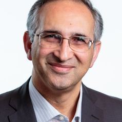
Scientific Program > Plenary SessionsPLENARY SESSIONS Keynote Speech by Pr Abbas RajabifardDigital Transformation-a new Era - Environmental Modelling by Digital Twins
Professor Abbas Rajabifard is an internationally recognized scholar and geospatial engineer and is an active leader in sustainability and resilience, land system modernization, and the development of Digital Twin platforms for the urban systems. He is Director of Smart and Sustainable Development, and Director of Centre for Spatial Data Infrastructures and Land Administration at the Faculty of Engineering and IT, the University of Melbourne. He is also a Board Member of the United Nations-Academic Network for Global Geospatial Information Management (UN-GGIM), which is a research and training arm of the UN to support SDGs. Prof Rajabifard has led multiple major projects nationally and internationally over 20 years representing a total grant income of more than $35m, in improving urban sustainability and resilience, modernization of land administration systems, and advancement in 3D mapping and location intelligence and digital twin systems design and development. Over the last decade, he has contributed to the leading science panels and consulting projects advising, Victorian and other government agencies nationally and internationally dealing with land and geospatial information policy and management. He has particularly worked and consulted on strategic projects in Asia-Pacific, Europe, North America, and Latin America regions, where he has developed the strategy, design, and implementation of policies and technologies. Abstract
With this in mind, digital analytical tools and location Intelligence are becoming very important and useful for wide range of activities, such as understanding climate data, assessing variability, predicting extreme weather events, or climate change’s socio-economic impacts. They can also enable an efficient, transparent, decentralized decision-making processes, while also supporting decision-making processes at different jurisdictional levels. By addressing conventional challenges in an unconventional way, digitalisation can boost adaptation capacity and climate resilience for communities in both more and less developed regions. This presentation, discusses current trends on digital analytical capabilities, location intelligence and digital twin as an enabling platform. Digital Twin is an opportunity for us to lead the generation of Scientific Evidence and prepare for the future challenges ahead. This would allow us to better understand our changing environment and support our societies using location intelligence and digital capabilities and technologies.
Keynote Speech by Dr Willem VervoortProviding research to manage and guide landscape-scale sustainability Dr Willem Vervoort has a PhD in field hydrology from the University of Georgia in the US and Agricultural Engineering undergraduate degree from Wageningen University. Willem is the leading hydrologist at The University of Sydney and an expert in quantitative Hydrology and Catchment Management and simulation modelling. His main research focus is on sustainable water management to balance climate and human impacts. He has a specific interest in agricultural management and impacts. Willem combines remote sensing, field data and simulation modelling to develop quantitative tools scaling from the field to the continent. Current projects include Bayesian model optimisation, multi-objective model optimisation, understanding model uncertainty in relation to observed water quality and quantity, and the use of satellite data to improve model structures and predictions. Recent work developed soil moisture predictions for Australia and water accounting tools from the field to the landscape. Willem has extensive experience working with industry in projects with the Cotton industry, Grains industry, Icon water, and more recently with a European/Australian consortium of SME in the water value chain. Willem has worked in Indonesia, Uruguay, Mexico and India, delivering capacity building programs and management advice. He is currently advising the Uruguayan Agricultural research institute on future research directions in water. Abstract
Developing effective management and policy to encourage sustainable agriculture, which requires the ability to monitor, predict and forecast impacts of changes. Particularly in Australia, but across the world more generally, this is difficult because natural climate variability and now climate change also creates year on year changes in impacts. The challenge is to develop tools that can separate the different signals, supported by quantified uncertainties. Much of the deterministic modelling is complex to be developed for large landscape scale processes. Even more advanced models integrate processes to larger scales because computationally and conceptually, fully deterministic modelling is not yet achievable. Using statistical modelling, signals in data can be identified, but linking signals to processes is still challenging. Providing direct links to deterministic processes combined with statistical modelling will progress this area. Satellite data are an important new data source to identify processes, but the approach suffers from sale issues and current satellite data can only infer processes. Quantifying uncertainties is important, as this can focus investment for sensing and research, as well as providing probabilities for risk assessment. However, a key component for translating research into policy, management and action is interaction and co-development of research with stakeholders and partners outside academia. The most impactful research also develops feedback loops where stakeholder input can be incorporated into the development of further research. Future sustainable landscape management will have to build on all these different approaches as past research shows that often a single approach is not comprehensive enough and often fails to have real impact. |


